|
Map Of Brazil
About Map Of Brazil
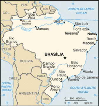
Brazil is located in South America on the Atlantic coast and is bordered by the Atlantic Ocean and most of the South American countries in the vicinity, with the exception of Ecuador and Chile. These are:
Brazil happens to be the fith largest country in the world and is considered by Brazilians to be a continent in its own right. Brasil covers in excess of more than half of South America, having a unique geographic diversity that is second to none.
As you can see from the physical map of Brazil, Brasil is massive in terms of its land mass although this is not reflected in terms of its population size, estimated to be in the region of 185.990.230 inhabitants.
The islands of Sao Pedro and Sao Paulo Fernando de Noronha Trinade and Martin VazBrazilian, which are to the east of the image below (right), are also Brasil's territory.
Brazil consist of 26 States and a Federal District. You can find further information on maps of Brazil and each of its states to help you learn more about each. This will be especially useful in identifying a particular state and its geographical location when planning your travel to Brazil northeast coast.
For example, if you plan to travel to Brasil northeast region, then a Brazil map of that particular state or a much more narrow area of that region will prove highly beneficial.
When used in conjunction with the rest of the information throughout this web site and a good travel guide book with maps, the Brazil map and maps of individual states can act as an extremely useful resource and geographical guide that will help you in the following ways:
Reference: Maps courtesy of Wikipedia
Brazil Maps
Brazil's Geography
Access the Brazil Flag here
Brazil Flag
Return From Map Of Brazil To Brasil Travel Northeast Home
|